Discover the UK’s best traffic-free cycle routes
Below are some of the most recent route guides, but be sure to visit the UK-wide map, showing all the route guides. All routes have a custom WillCycle map, from which you can download the GPX for the route, and where you can see the route profile in detail.
The route guides include an up-to-date weather forecast, and lots of information about the route. It even tells how how long it would take to cycle, at your preferred speed.
Featured routes
These are just some of the stunning routes I have highly-detailed guides for. Refresh the page to see more routes.
Even more value
WillCycle Supporters gain even more value, including achievement badges, and more, as well as Strava integration.
These route guides are all made with 🚲 in Devon.
Latest from the blog
- Police Failure
 For a long time now, I stopped using WillCycle to do direct cycling advocacy, but something happened recently that forced my hand, hence this post. Devon and Cornwall Police and I have a bit of a history. When I originally started making complaints about bad driving, with supporting video, I was laughed off. An Inspector … Read more
 - The future’s so brightI haven’t posted anything new on WillCycle for what feels like an eternity. I haven’t been slacking though. No, I’ve been extremely busy on the back-end of the site. New features WillCycle now has what I can honestly describe as a superb mapping system. It started off as an idea, quite some time ago, to … Read more
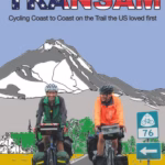
- TransAm, by Paul K W Duntin 1976, the TransAmerica coast-to-coast cycling trail was launched, as part of the USA’s bicentennial, and since then, many thousands of cyclists, from around the world, have cycled the route. One such cyclist is the ever-amazing Juliana Buhring (who makes a cameo appearance in this book). However, the most remarkable stories about the TransAm comes … Read more
- Fairy TrailsDo you ever go cycling, or walking, with young kids? What if I told you that you could easily add a bit of magic to those outings? How? By doing Fairy Trails! Fairy Trails are being embedded into more and more of the traffic-free cycle routes listed on WillCycle. To play, simply visit the route … Read more