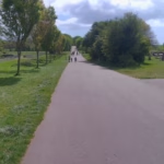
Discover the UK’s best traffic-free cycle routes
Below are some of the most recent route guides, but be sure to visit the UK-wide map, showing all the route guides. All routes have a custom WillCycle map, from which you can download the GPX for the route, and where you can see the route profile in detail.
The route guides include an up-to-date weather forecast, and lots of information about the route. It even tells how how long it would take to cycle, at your preferred speed.
Featured routes
These are just some of the stunning routes I have highly-detailed guides for. Refresh the page to see more routes.
Even more value
WillCycle Supporters gain even more value, including achievement badges, and more, as well as Strava integration.
These route guides are all made with 🚲 in Devon.
Latest from the blog
- TransAm, by Paul K W Dunt
 in 1976, the TransAmerica coast-to-coast cycling trail was launched, as part of the USA’s bicentennial, and since then, many thousands of cyclists, from around the world, have cycled the route. One such cyclist is the ever-amazing Juliana Buhring (who makes a cameo appearance in this book). However, the most remarkable stories about the TransAm comes … Read more
 - Central ParkNo, not that Central Park. This route runs through Central Park, in Plymouth. The land that forms Central Park is held in trust, and may only be used for leisure facilities, for the people of Plymouth. Started in 1928, and formally opened in 1931, despite what the local legend says, Plymouth’s Central Park isn’t older … Read more
- Fairy TrailsDo you ever go cycling, or walking, with young kids? What if I told you that you could easily add a bit of magic to those outings? How? By doing Fairy Trails! Fairy Trails are being embedded into more and more of the traffic-free cycle routes listed on WillCycle. To play, simply visit the route … Read more
- Treasure Hunt: A Cycling Adventure You Can’t Plan ForSomewhere along some of WillCycle’s traffic-free routes, there are stickers hidden. Those were been placed there deliberately, in a spot that requires effort to reach. It won’t appear on any map. Nobody is going to tell you where it is. And the first WillCycler to find it and send proof will have their first name … Read more